Sunday, June 1, 2014

Kent Island Day 7

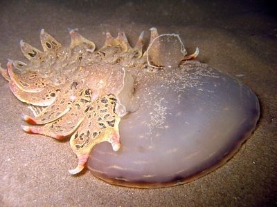
Ciona intestanlis ascidian overgrowing mussel aquaculture cage on PEI. Bullard et al. (2009).
This past week has been quite a reality check in terms of the scientific method for me. Even with a well-planned project and an entire coastline of 5 miles accessible to work, one's hubris is easily squashed by an unfortunate ignorance of larval settlement times. Realizing that my Bryozoan might not show up until July, if at all, I came to the realization yesterday that it was time to brainstorm a new project.

As I mentioned in a previous post, I am deploying a settlement plate for a PhD student at UConn and gathering data for him on the diversity and percent cover of "fouling organisms". This side project was related to my initial project in that it examines the larval settlement and growth of invasive species including my Bryozoan (Membranipora) but also several species of Ascidians, better known as sea squirts. Ascidians have become infamous in harbor communities as nuisance species, overgrowing lobster pots, buoys, lines, docks, boats, and aquaculture cages. They greatly increase the weight and drag of these objects and cost millions each year since their introduction in the Maritimes in the 1990's. Further south in Salem, Mass, lobster pots that were once hauled in by hand now have to be winched in, and even now some are so covered that they are deemed too dangerous to haul in, since they may cause catastrophic winch failure.

The data collected from the settlement plates (essentially PVC squares hung in 1m of water) are collected via photographs of each plate every week. The images are then analyzed using photo software to determine percent cover of each species present. This, coupled with water temp readings, will determine settlement and development rate of native and invasive fouling organisms and will be analyzed with data from all over the eastern seaboard to look at temperature and spatial impacts on fouling organism growth. One question that is trying to be answered is the effect of climate change and warming waters on the settlement, growth, and dispersal of fouling organisms, particularly invasive species.

With this project in mind, I've decided I am  going to analyze settlement plate data from around Kent Island and Grand Manan and compare that to data obtained from Bowdoin's Coastal Studies Center, in southern Maine. At this point I am still deciding on a methodology and hypothesis, but it looks like I will be looking at the affect current has on the dispersal and settlement of fouling organisms with particular emphasis on invasives like the ascidians or even my Bryozoan if it shows up. So I will be making more plates and deploying them in the protected and pristine harbor formed by Kent, Hay, and Sheep Islands, two off the northern and southern ends which are exposed to currents formed by incoming and out-flowing tides of the Bay of Fundy, one or two in the protected but heavily trafficked Seal Harbor, and one at the Coastal Studies Center in Maine. In addition, I might be deploying plates off of the ubiquitous salmon aquaculture cages scattered throughout the Grand Manan archipelago as well as snorkeling around them to examine settlement on long-immersion structures. Aquaculture cages sit in the water for years, and unless removed for cleaning accumulate all sorts of fouling organisms. These fouled nets can limit water exchange between the interior and the ocean, and allow nutrients to accumulate to dangerous levels within the cage. Removal of these organisms causes up to 80% of maintenance costs, since mechanical removal is tedious and inefficient and chemicals too dangerous.

So I do have options now, albeit ones that are incredibly time intensive. But fingers are crossed that this project can go ahead as planned, since it is not dependent on the arrival of any one organism.

The days here are still bird-shell blue, and last night was an incredibly warm (for us at least, 60 degrees is warm) night. We took a petrel walk around midnight to listen for the gremlin calls of the little birds as they came back from fishing at sea to roost in their little burrows. They are extremely clumsy on land for such graceful aeronauts, and crash into trees on their decent down before finally arriving on the ground, where they proceed to stumble drunkingly about emitting giggling cackles. One strolled across our path in a very blasé manner, letting us see the robin-sized seabird a close range. It is amazing that these birds, which travel hundreds or thousands of kilometers out to sea to fish before returning to their nest, are so small. It is a wonder that they are not at the complete mercy of the winds.

Back to planning!

A Storm petrel in its Burrow. Photo cred Drew Fulton

Friday, May 30, 2014

Kent Island Day 5


It's been sunny the past couple days which has made everyone forget all about the fog and rain that had heralded our arrival on KI. Although it's still cold at night and almost impossible to leave one's sleeping bag for 6AM low tides, the days are warm and sunny except for a few foggy hours in the morning meaning lots of electricity and hot water.

 While everyone else has been busy working on their respective project, I find myself to be unfortunately without much work to do. As I said in my first post, I am waiting for my invasive Bryozoan to show up hopefully sometime soon, although I have no idea when - a Washington state lab lists settlement as occurring in June, while a paper from Newfoundland lists August. There is also the possibility that since KI lies near a convergence in ocean currents, with one arm heading north up the Bay of Fundy and the other half southwest along the Maine coast, there is no strong dispersal mechanism for the planktonic larvae (cyphonauts) of the Bryozoan. In other words, they won't reach KI and so I will never find them, even if I stay into August. Therefore, there is a lot of uneasy waiting currently. I am spotting kelp-filled pools all over the island, which tells me there is no shortage of substrate for the larvae to settle on. But so far, other than an exciting find of the native Bryozoan Electra pilosa on some Irish Moss, no bryozoan has shown up.

http://www.marinbi.com/bryozoa/membranipora_membranacea.jpg
The species in question: Membranipora membranacea. Each rectangle is a separate animal, altogether forming a single encrusting mat (colony) over kelp. Image courtesy marinbi.com


So I've been doing a lot of wandering aimlessly at the low tide line twice a day and a lot of chores at the other times. Today, I deployed a settlement plate as part of a PhD student from UConn's work. Essentially, I just suspend 8 ceramic plates in the water column from a floating buoy and every week take pictures of the organisms which have settled on the plates and started to grow from their planktonic juvenile forms. A lot of these organisms are invasive sea squirts (tunicates) as well as other invasive Bryozoans - I have hope that my Bryozoan will show up sometime soon on the plates, which will be a good indicator that they have settled elsewhere naturally on the island. So while this data is going to the project of someone else, I can also use the data as a back-up project. Such is the nature of science - things fall apart. One can never be certain of getting data even if you do everything right.

Onchidoris muricata which appeaers to be feeding on M. membranacea or Electra pilosa. Another organism I have yet to find on KI. Image courtesy of seaslugforum.net


Membranipora membranacea
Membranipora membranacea on kelp. Image courtesy vitalsignsme.com
 Pray for fog.

Thursday, May 29, 2014

Some pics

As promised here are some pics of Kent Island that I've managed to snap so far.
The dorm by the dock

 A surprisingly sunny afternoon
 Herring gull eggs with the ever ubiquitous trash washing up on the island
 A view down island
 Driftwood
 Sundews

The Bowdoin and Kenyon crew walking towards South Hill

Wednesday, May 28, 2014

Kent Island Day 3


I was fortunate enough to receive a grant to conduct research on Kent Island, a Canadian island in New Brunswick just a few miles south of Grand Manan this summer, and I hope to keep this blog updated with research and general island life as long as the solar power and radio-signal internet allow me to.

We arrived two days ago after driving four hours to the Canadian border and over to Black’s Harbor. From there we took the Grand Manan car ferry, and then drove to Seal Cove on Grand Manan where we loaded up our mountain of gear including food for two months, personal gear, and research equipment, onto one of the wide Canadian lobster boats. We arrived at KI after an hours boat ride and soon found ourselves in a rainstorm as we sat in three island harbor, the protected area between Kent Island and the smaller uninhabited islands of Hay and Sheep. Since Kent Island is located in the Bay of Fundy, the tides are some of the most extreme in the world – the dock accessing the island lies high and dry for almost a third of each day. At this particular time we were arriving at the island at low tide, where we had to navigate amidst a labyrinth of rocky reefs. We could only land people in a small tender, and so we landed with only a backpack’s worth of gear for the night until we could retrieve the majority of our gear at a later time.

The island has several buildings, two of which were standing in 1937 when the Island was given to Bowdoin College – a sheep barn (which now is the kitchen, library, and a dorm) and a small shed on the dock (which now houses a tender on the first floor and a dorm for two people on the second). I am staying in a structure close to the dock which holds a small lab on the first floor and three beds on the second. While we do get amenities such as solar power, radio-signal wifi, limited cell strength, and a solar water heater, we do get the joy (and I’m not being sarcastic) of outhouses and no heating as well as some pretty extreme isolation save an eclectic mix of scientists, artists, and seabirds. We have researchers and students from the University of Guelph, Kenyon College, and of course Bowdoin. Ornithology is the main draw to this rock, with studies from the 1940’s to present on Storm Petrels being conducted as well as projects on Guillemots, Savannah Sparrows, and others. Two other students and myself are doing work on the intertidal, and four students are doing art projects ranging from science journalism to fiction writing to composing electronic music from ambient island sounds. I will post more about their projects as I learn about them in the weeks to come.

A quick note on island habitats – I’ve noticed three of them so far, although there are maps describing twenty or so habitats. There is the forest on the northern edge of the island, reaching south the main buildings. It is in these woods that the Storm Petrels nest in burrows and let out eerie goblin squawks at night. One area of the forest is so covered in burrows that it is called, appropriately, The Shire. To the south lies a vast expanse of open fields, grassland, and marsh – it is here that many other birds like the sparrows and gulls nest. To the extreme south lies three hills, the tallest called South Hill. These highlands are covered in raspberry bushes and seem barren except for a few gull nests. These gulls have been laying their clutches of three speckled eggs in their ground nests all over the island, especially near the rocky shore. Damon Gannon, the advisor and director of the research station, tells us that in two or three weeks the gulls will begin to attack anyone who walks by. There is a reason hard-hat helmets are kept hanging in the mud room of the dorm. But for now they just stare sardonically at us through malevolent yellow eyes and shriek at passersbys.  

Although one could live the two months on the island just observing the landscape without being bored, I do have to do my project. Briefly, I will be looking at the interactions between an invasive Bryozoan (Membranipora membranacea) and kelp (Laminiaria) as well as the interaction between the bryozoan predator Onchidoris muricata, the bryozoan, and the kelp. The bryozoan is an invasive species native to the eastern Atlantic and Mediterranean as well as the Pacific, but was introduced to the eastern seaboard in 1987, first noticed by divers at the Isle of Shoals in NH/ME. The bryozoan overgrows the native kelp due to a lack of predator interest and it is predicted to cause breakage of kelp fronds. Since the bryozoans are composed of hundreds of individuals forming a single colony with walls of calcium carbonate, the kelp fronds become quite rigid and can break in the strong currents. Kelp provide a unique architecture in an otherwise current-swept rocky shore, and can shelter the seafloor from strong currents. This is similar to the windscreen effect of a forest compared to an open plain. So, I am predicting that kelp that display frond breakage as a result of bryozoan overgrowth will have a lower diversity of benthic organisms directly underneath affected kelp forests. In addition, I will be transplanting affected and clean kelp to a high-current area to examine the extent of current breakage and manipulating placement of the kelp within the flow area to more or less protected areas to find the limit of frond survival when affected. Lastly, I will be examining if predation by the nudibranch O. muricata will effect frond breakage. We know that the nudibranch does not eat enough of the colony to completely eliminate it, but I want to see if by eating patches in the bryozoan colonies, the breakage rate can be decreased by decreasing the total rigid area that is unbroken. The methods of all of this I will go over later when I know my methods better.

Currently, I am waiting for the invasive bryozoan to settle out of its juvenile planktonic form and grow colonies – they won’t be visible until mid-June. So I am currently scoping out kelp beds around the island that can be accessed via wading or snorkeling.

I will post pictures later but my battery is low, internet is waning, and I have to get up for 6am low tide tomorrow. 

Pray for fog.

Friday, December 14, 2012

Five of the Coolest Nudibranchs plus a Freebie

I've decided to start posting about some of the coolest critters you'll find in the Oceans, there is a ton of taxonomic and evolution weirdness that is just not talked about nearly enough.

So here is a list of the five coolest Nudibranchs in my opinion. There are definitely more colorful Nudibranchs out there, but in terms of morphological weirdness/interest these are kind of at the top.

1) Tethys fimbria

Photo cred Dominique Horst (www.bathymed.net)
This thing is just weird. It is the only species within this genus, and frankly nothing else looks like it. It is related to the predatory Melibe, itself an interesting animal in that it actively hunts copepods and other tiny shrimp-like crustaceans by enveloping them in their giant oral hood. Like a diabolical fishing net, or an aquatic venus flytrap. Here is a video for you to get an idea of how Melibe hunts.

Creepy. Tethys feeds in the same manner, which would be cool enough by itself. But then you realize how BIG Tethys can get - almost 30 cm. Nudibranchs usually don't get much bigger than 10cm, and the colorful ones are tiny. 30 cm is massive for an invertebrate, especially for a shell-less organism like Tethys. Finally, the thing reminds me of a trilobite. Look at this video; coming up to it, it looks like we are entering a primordial coral reef. Interesting example of convergent evolution in terms of body shape (maybe?) who knows, maybe trilobites used their head to entrap small organisms.
2) Dendronotus comteti

Valdes et al. 1998


I've written about this nudibranch before (Dendronotus comteti), and I am still fascinated by its biology. It's no looker, but it is the only nudibranch to be found at hydrothermal vents (and I think the nudibranch found at the greatest depth - not sure about that one). Anything found at depth and in such an extreme environment is already of special interest, but to have one species representing an entire Order (which is a lot of species) is quite impressive. I believe that there must be more species of Nudibranchs down on hydrothermal vents/cold seeps/what have you, but so far this is all we have.

3) Hermosita hakunamatata

Photo cred Peter Ajtai
 It's a nudibranch named after the Hakuna Matata. Enough said.

4) Onchidoris bilamellata

Photo cred Me. Yay!
 Onchidoris bilamellata is (or was) my pet project/nudibranch species for a while. It is unique in that it can be found in huge numbers here in the Northeast (especially in Maine where I did a project on their biogeography in high school five years ago. I've typed up the entire report on a google site for all to see. Please excuse the layout/scientific methodology used; I was 14 when I started the project Check it out!!) Fascinating life history, and because they have spawning aggregations in such great numbers, it is relatively easy to find them and study their behavior.

5) Glaucus atlanticus


 Any list of any nudibranchs has to cover G. atlanticus. This are undoubtedly the funkiest nudibranchs out there - They adhere to the ocean surface via surface tension (you are seeing the oral side i.e. the belly in this picture - they float upside down) and munch away on Physalia physalis, or the Portuguese Man O' War, an extremely nasty hydrozoan (not a jellyfish as many people think). These nudibranchs are able to avoid being stung and even use the stinging nematocysts found within the Man O' War tentacles to their own advantage by ingesting them and forming their own nematocysts on their cerata. Gorgeous animal, definitely by top 1 nudibranch to see alive. FREEBIE - This organism always remind me of Velella velella, or the By the Wind Sailor (also a hydrozoan - and one of the best names for an invertebrate) because it too has a striking blue/white coloration. Like the Man O' War, it too is pelagic but doesn't have a sting felt to humans. Simply a gorgeous animal.
Photo cred A.F. Julien

Monday, October 15, 2012

One of the blogs I follow regularly, Deep Sea News, recently posted an article about the resurrection of a geoengineering project called Planktos, founded by businessmen Russ George, which you can read here. His company became bankrupt a few years ago after severe pressure by environmentalists and scientists halted the main project of the business, plankton seeding.
   
    The idea was that phytoplankton, who use Iron naturally found in seawater for photosynthesis, would thrive on a massive dumping of iron fillings into the ocean and cause an algal bloom. This huge bloom would then fix the carbon dioxide in the oceans - boom, climate problem gone. He recently tested it off the coast of British Columbia, where it indeed caused a huge algal bloom (see this article and map from the Guardian). So in theory yes the artificial addition of iron worked in that an algal bloom occurred, although a bloom much larger would have to occur if a dent was to be made in carbon dioxide amounts in the ocean.  So what's the problem?

     Disregarding the UN's international treaty on geoengineering signed by 191 countries a few years ago, we simply do not know what the affects of such radical artificial geoengineering would be. The impact to benthic communities would be hit particularly hard as hypoxia spreads towards the bottom of the ocean as bacterial communities gorge themselves on the billions of dead phytoplankton floating down from the surface because of the rapid increase in phytoplankton population. Unused iron could alter benthic community dynamics, and it is not clear how well the carbon could be contained - in other words, whether the carbon will just cycle back into the form of carbon dioxide within a few years. At the surface, toxic waters (i.e. red tides) could spring up, harming fisheries. And finally, it is possible that this method could even worsen climate change.

    I am not passing judgement yet - I will be interested to see what the affects of the bloom will be on the local fisheries and benthic communities in the next few months to years. So while I do love reading Deep Sea News, I take issue with their current article as it preemptively condemns the 'experiment'. I am in no way justifying George's action, nor am I saying that sound science lays behind it, but I would rather wait for data (even if it is likely to prove the dump was a terrible idea) to come out before it is deemed a failure/crippling blow to the environment.

    Another reason I hesitate to immediately condemn the dumping is the simple lack of solutions. While I believe geoengineering to be the absolute last resort to the climate problem, there simply aren't a lot of companies out there who are in a position to help reduce greenhouse emissions as a primary goal. I think Planktos should have definitely undergone some serious smaller scale experiments are even drop geoengineering altogether - a company that is attempting to help preserve the climate and biodiversity (they have a reforestry project as well that I have not as of yet investigated) using a business model that attempts to make the environment profitable a boon. I know, I've scourged the internet for hours looking for jobs/internships in Marine Conservation - there simply aren't that many. I believe the only way we can fix the climate problem is to make being green (or blue if you prefer) profitable to the right companies while still providing the resources that people need (not want). So while I do not support geoengineering, I am saddened to see another company attempting to profit off of Conservation (in a good way!) go down.

    Investigate Planktos and George for yourself. I think you will agree that while the the events that model provided by George are far from the best, conservation driven businesses can be the thing to reduce climate emissions and preserve biodiversity.


Monday, October 1, 2012

My internship may have ended, but the show of marine awesomeness must go on!

The Ikka Carbonate Columns, Ikka Fjord, Greenland - the coolest underwater geological structures ever. They form from underwater seeps of Carbonate to form a mineral called Ikaite, which form these sweet pinnacles. But they are disappearing fast, most likely as a result of ocean acidification. The pinnacles are essentially dissolving as the surrounding ocean becomes more neutral, so withing a few decades these will be gone.

Put it in full screen, HD. The action starts around 2:00 if you are lazy.

Definitely on my list of top 5 places to dive.